
Laser Scanning
3D laser scanning is rapidly becoming an industry standard for small-scale as well as large-scale projects. Advancements in hardware, software, and workflows have made laser scanning a viable option for projects of all sizes. Laser scanning allows our surveyors to collect tremendous amounts of precise data at high speeds.
Here’s how it works: 3D laser scanning is a non-intrusive means of rapidly collecting detailed and accurate data for project documentation. A 3D laser scanner emits a narrow, eye-safe laser beam that sweeps across a target area, such as a bridge, roadway or building, gathering millions of closely spaced measurements (points with a unique X, Y, and Z, values) in a matter of minutes. These scanned measurements are collected and grouped into a comprehensive point cloud database that can be easily manipulated on a standard desktop or laptop computer. This data can be viewed, navigated, and analyzed much like a 3D model created in a traditional CAD system. Virtual walkthroughs, interference detection, containment analysis, interactive 3D models, demolition plans, critical move plans, quantity takeoff, inventory management, and deformation analysis are just a few of the possible uses for HDS.
McNeil Engineering’s 3D Laser Scan team relies on our technical experience and specialized expertise to create personalized solutions for our clients. We use high definition laser scanners, total stations, and modeling and point cloud software to provide comprehensive, record surveys, 3D CAD models and detailed 2D isometric drawings. We look forward to showing you how this innovative approach to surveying can work for you.
Applications
Mining: Volume & Topographic Surveys
Intrepid Potash – Wendover & Moab, UT
Skyline Mine – Helper, UT
Cactus Mine – Milford, UT
Airports:
Wendover Airport – Wendover, UT
LAX – Alaska Airlines – Los Angeles, CA
Hill Air Force Base – Layton, UT
Transportation:
UDOT, Taggart Bridge – Morgan, UT
205th Street – Torrance, CA
9000 South Pedestrian Tunnel – West Jordan, UT
Roosevelt & Lexington Subway Stations – New York City
4000 West – West Jordan, UT
I-215 (Redwood Road to 4700 South) – Salt Lake County
Historic Preservation:
Masonic Temple – Salt Lake City, UT
Garfield School – Salt Lake City, UT
Casino Star Theater – Gunnison, UT
Capitol Theater – Salt Lake City, UT
Mumbai Mosques – India
Industrial/ Refineries:
Morton Salt, Dryer Facility – Grantsville, UT
Cargill Salt, Cyclone Project – UT
Tesoro Refinery – North Salt Lake, UT
Big West Oil – North Salt Lake, UT
Holly Refinery – North Salt Lake, UT
Huntington Power Plant – Huntington, UT
National Oil Varco – Evanston, WY
Settlement/ Movement Studies:
Park City Residential Drive Way – Park City, UT
Kari Circle – North Salt Lake, UT
Judge memorial High School, Football Field – Salt Lake City, UT
Pearl Harbor – Hawaii
Crane Rail Survey – Kemmerer, WY
Project Examples:
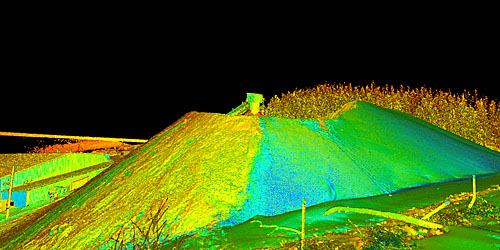
Mining: Volume & Topographic Surveys
Skyline Mine, Helper, UT
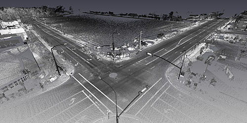
Transportation Survey
13200 South, Riverton, UT
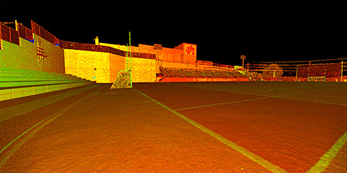
Settlement/ Movement Studies
Judge Memorial High School Football Field, Salt Lake City, UT
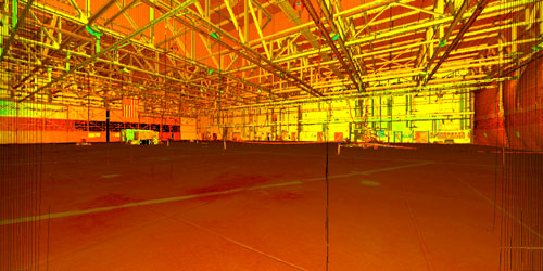
Airports
Airplane hangar – Utah
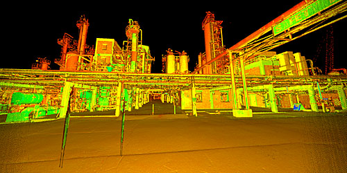
Industrial/Refineries
Refinery – North Salt Lake, UT
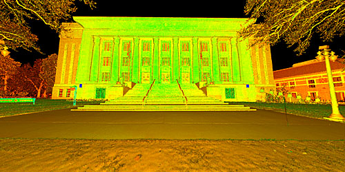
Historic Preservation
Masonic Temple – Salt Lake City, UT