What is laser scanning and how does it help you?
 As a tool, laser scanning is finding more and more applications in a wide range of industries, from manufacturing to high tech and even in agriculture. We at McNeil Engineering are leaders in the application of laser scanning to surveying, 3D modeling and Building Information Modeling (BIM).
But the real importance of laser scanning lies in the benefits it provides to our clients: better, more accurate and complete surveys and building models faster and more economically. Let us walk you through how that happens.
What is laser scanning?
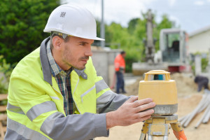
Laser scanning uses a controlled deflection of laser beams to gather information about a site or any three-dimensional space.
Movable mirrors deflect continuous or rapid pulses of laser light (a tightly focused beam that does not diverge like conventional light) in both the vertical axis and horizontal axis. A scanner then records the reflections off of surfaces, as well as the angle of the emitted and reflected light and the distance, 50,000 times per second. Other information can be associated with every single data point, such as geo-referenced data. A camera also records visual information that is merged with the other data.
The scanner can be moved to different vantage points at a potential construction site or within a plant (for example). The data sets collected can then be combined.
Laser scanning software then uses these billions of survey points to create a three-dimensional model of the survey. This is also called a “point cloud.” The point cloud can be imported into computer-aided design (CAD) software to build topographic survey maps that are rich in data.
Uses
A point cloud creates a full model of a site, a building or a project that is beyond three-dimensional. Combining photographs, CAD software then produces an array of deliverables quickly and accurately:
- two-dimensional plans and elevations
- panoramic images with georeferenced information for every pixel
- point-to-point and point-to-surface measurements
- full, detailed topographic maps with georeferences
- sections and profiles
- plant models showing structural elements
- fly-through models and more.
These rich models can also capture information on materials and other construction or engineering details. A single set of data can be used by every phase of a project: conception, architecture, planning, modeling, approval, construction planning, and execution. It means that all the professionals can work from the same data, reducing the opportunity for human error.
Laser scanning allows architects and engineers to quickly and easily “see” a project in the planning. The models can show such tiny yet critical details as surrounding topography, conflicts between load-bearing structures and conduits, clearances, ties points and profiles.
The data can be exported to produce detailed topographic maps, surface wireframe models, links to asset information, intelligent plant and building information models.
At McNeil Engineering, we use laser scanning for land title surveys, boundary and topographic surveys and 3-D, 4-D and 5-D BIM models.
Benefits to the customer
While laser scanning is a powerful tool for architects, engineers and construction contractors, it also has many benefits for the client, developer or building owner.
First, surveys, plans and models can be developed much more quickly and more accurately than with conventional methods. This helps control costs, especially in complex projects or those in remote or challenging locations.
The richness and depth of data allows the client to visualize the project before the first shovel breaks ground, evaluate options and make better decisions about design, construction, materials and other aspects.
Better, more complete models also mean there are fewer unknowns about a site or a project, reducing liability for the owner.
Talk to one of the experts on laser scanning and surveying at McNeil Engineering to find out how it can pay off for your next project.